Moisture and temperature perturbations in the course of convection development
1. Tropical convection and quasi-equilibrium hypothesis
 Tropical convective clouds are often thought of as a "mediator" acting against a large-scale forcing
destabilizing the atmosphere such as moisture convergence and surface heat flux.
This neutrizing effect of convection has been formulated by a school of scientists (initiated by
Aarakawa and Schubert, 1974) into the quasi-equilibrium hypothesis,
which has been widely accepted as the basis for many cumulus parameterization schemes.
Some recent studies, on the other hand, found observational evidence that urges updates to
the quasi-equilibrium hypothesis as originally postulated.
Satellite data are analyzed to explore the thermodynamic evolution of tropical and
subtropical atmospheres prior and subsequent to moist convection,
motivated to offer an observational testbed for convective adjustment central to
the quasi-equilibrium hypothesis.
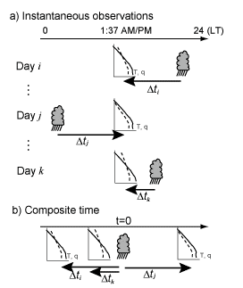
Tropical Rainfall Measuring Mission (TRMM) and Aqua satellite measurements are projected onto
a composite temporal sequence over an hourly to daily time scale by exploiting the temporal gap
between the local satellite overpasses that changes from one day to another (Figure on right).
The atmospheric forcing and response to convection are investigated separately for deep convective
and congestus clouds.
In the deep tropics,
a quick ventilation of atmospheric boundary layer (ABL) into the free troposphere is found
 in association with deep convection but is preceded by a steady buildup of ABL moisture,
which does not imply continuous adjustment to equilibrium.
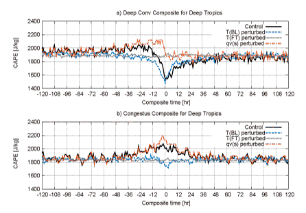
The evolution of convective available potential energy (CAPE) (black curve in left figure) is
controlled not only by the ABL moisture (red curve) but also largely by a coincident ABL cooling
(blue curve).
CAPE exhibits a rapid drop for 12 h preceding convection and a following restoring phase
lasting a day or two as the cool anomaly recovers (Left figure a).
The behavior of CAPE is quite different when moist convection is brought by congestus clouds with
no deep convection nearby. CAPE gently increases over a period of 1-2 days until congestus occurs
and then declines as slowly back to the initial level (Left figure b).
Convective adjustment is not efficiently at work even in the deep Tropics at times when convective
clouds are not developed so deep as to penetrate the whole troposphere.
2. Water and heat budget analysis
The above compositing technique is further expored with substantial updates to facilitate
a moisture and thermal budget analysis of the tropical atmosphere.
A variety of satellite sensors are employed including radars (TRMM PR and CloudSat radar),
an infrared and microwave sounder unit (Aqua AIRS/AMSU suite), and microwave radiometer (Aqua AMSR-E)
and scatterometer (QuikSCAT SeaWinds) aboard different platforms.
Satellite measurements of atmospheric parameters including air temperature, water vapor,
cumulus cloud cover, and surface wind are composited with respect to the temporal lead or lag
from TRMM detected convection to obtain statistically continuous time series
just as illustrated above.
 AIRS observed temperature and humidity profiles, representing cloud-cleared sounding, are
combined with semi-theoretical estimates of in-cloud temperature and humidity to construct
the large-scale mean field.
Those measurements are ingested to the moisture and thermal budget equations integrated vertically
over each layer separated by cloud base.
This strategy makes it possible to evaluate the free-tropospheric (FT) convergence of moisture
and dry static energy and their vertical flux at cloud base,
which was difficult to estimate from satellite observations alone.
The main findings include:
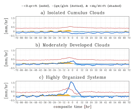
1) Vertical moisture transport at cloud base (dotted curve in right figure) is the dominant source
of FT moistening prior to isolated cumulus development (top panel)
while overwhelmed by horizontal moisture convergence (solid curve)
for highly organized systems (bottom panel);
2) FT diabatic heating is largely offset on an instantaneous basis as expected; and
3) FT moistening by convective eddies amounts to a half of the total cloud-base moisture flux
in the background state, while large-scale mean updrafts modulate the variability of cloud-base flux
when highly organized systems develop.
The known correlation between congestus clouds and FT moisture before deep convection may be
accounted for by large-scale mean moisture updraft rather than congestus eddy moistening.
Publications related to this topic
- Masunaga, H., 2012:
A satellite study of the atmospheric forcing and response to moist convection
over tropical and subtropical oceans
J. Atmos. Sci., 69, 150-167.
[PDF]
©
American Meteorological Society
- Masunaga, H., 2013:
A satellite study of tropical moist convection and environmental variability: A moisture and thermal budget analysis
J. Atmos. Sci., in press.
[PDF]
©
American Meteorological Society
Back to Research Page
 Tropical convective clouds are often thought of as a "mediator" acting against a large-scale forcing
destabilizing the atmosphere such as moisture convergence and surface heat flux.
This neutrizing effect of convection has been formulated by a school of scientists (initiated by
Aarakawa and Schubert, 1974) into the quasi-equilibrium hypothesis,
which has been widely accepted as the basis for many cumulus parameterization schemes.
Some recent studies, on the other hand, found observational evidence that urges updates to
the quasi-equilibrium hypothesis as originally postulated.
 in association with deep convection but is preceded by a steady buildup of ABL moisture,
which does not imply continuous adjustment to equilibrium.
The evolution of convective available potential energy (CAPE) (black curve in left figure) is
controlled not only by the ABL moisture (red curve) but also largely by a coincident ABL cooling
(blue curve).
CAPE exhibits a rapid drop for 12 h preceding convection and a following restoring phase
lasting a day or two as the cool anomaly recovers (Left figure a).
The behavior of CAPE is quite different when moist convection is brought by congestus clouds with
no deep convection nearby. CAPE gently increases over a period of 1-2 days until congestus occurs
and then declines as slowly back to the initial level (Left figure b).
Convective adjustment is not efficiently at work even in the deep Tropics at times when convective
clouds are not developed so deep as to penetrate the whole troposphere.
 AIRS observed temperature and humidity profiles, representing cloud-cleared sounding, are
combined with semi-theoretical estimates of in-cloud temperature and humidity to construct
the large-scale mean field.
Those measurements are ingested to the moisture and thermal budget equations integrated vertically
over each layer separated by cloud base.
This strategy makes it possible to evaluate the free-tropospheric (FT) convergence of moisture
and dry static energy and their vertical flux at cloud base,
which was difficult to estimate from satellite observations alone.