Tropical Precipitation Spectrum
Precipitating clouds in the Tropics can be classified into a few different
components in terms of cloud height and rain heaviness.
The most abundant component is shallow cumulus.
Shallow cumulus does not reach the freezing level (the height at which
temperature equals 0oC) and produces moderate rainfall
in the absence of frozen hydrometeors.
Cumulus congestus grows to above the freezing level,
yielding more rainfall than shallow clouds,
although the cloud top is not as high as tropopause (i.e., the boundary between
the troposphere and stratosphere).
A deep convective core is a tall cumulus tower penetrating the whole
troposphere, where rain drops melted from large ice particles (snow, graupel,
and hail) created above the freezing level result in heavy rainfall.
Deep convective cores are often surrounded by stratiform rain.
Stratiform regions tend to be less turbulent and lower in rain rate than
deep convective cores, while stratiform areas produce rainfall across a much
wider area than convective cores do.
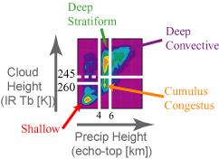 The figure on the right shows the joint histogram of precipitation height
and cloud height analyzed from Tropical Rainfall Measuring Mission (TRMM)
*1 satellite data.
"Precipitation height" is defined as the radar echo-top height measured by
TRMM Precipitation Radar (PR).
Infrared (IR) brightness temperature (Tb) observed by
TRMM Visible/Infrared Scanner (VIRS) is used as the proxy of "cloud height".
The histogram exhibits distinct features corresponding to various members of
tropical precipitation: Shallow (very warm cloud tops with low echo-top
heights), Cumulus Congestus (warm cloud tops with echo-top
heights around the freezing level or 4-6 km), Deep Stratiform
(cold cloud tops with echo-top heights around the freezing level), and
Deep Convective (cold cloud tops with high echo tops).
These four types of rainfall systems are hereafter called
storm categories.
The figure on the right shows the joint histogram of precipitation height
and cloud height analyzed from Tropical Rainfall Measuring Mission (TRMM)
*1 satellite data.
"Precipitation height" is defined as the radar echo-top height measured by
TRMM Precipitation Radar (PR).
Infrared (IR) brightness temperature (Tb) observed by
TRMM Visible/Infrared Scanner (VIRS) is used as the proxy of "cloud height".
The histogram exhibits distinct features corresponding to various members of
tropical precipitation: Shallow (very warm cloud tops with low echo-top
heights), Cumulus Congestus (warm cloud tops with echo-top
heights around the freezing level or 4-6 km), Deep Stratiform
(cold cloud tops with echo-top heights around the freezing level), and
Deep Convective (cold cloud tops with high echo tops).
These four types of rainfall systems are hereafter called
storm categories.
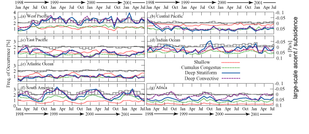 Relative significance among the different storm categories varies with
geographical regions, seasons, and ENSO*2
phases.
Time series of the probability of rainfall occurrence are plotted separately
for different storm categories and for various tropical regions.
Deep Stratiform and Deep Convective systems are observed more often than
Shallow and Cumulus Congestus clouds in the West Pacific and Indian Ocean.
In contrast, the Shallow category is the dominant component most of the
time in the Central Pacific.
A key to understand this regional contrast lies in large-scale ascent or
subsidence indicated by histograms.
Deep Stratiform and Convective systems are commonly found in association
with large-scale ascent (upward bars), while they tend to be overwhelmed
by Shallow clouds in the absence of strong ascent or under subsidence
(downward bars).
Deep systems can warm the surrounding atmosphere by latent heat release,
which works as a pump to generate large-scale circulation.
The subsiding branch of the circulation caps the lower troposphere known as
the planetary boundary layer (PBL).
This cap, or the trade inversion, suppresses deep convective activity.
It only allows shallow cumulus to barely pop out of the PBL.
Relative significance among the different storm categories varies with
geographical regions, seasons, and ENSO*2
phases.
Time series of the probability of rainfall occurrence are plotted separately
for different storm categories and for various tropical regions.
Deep Stratiform and Deep Convective systems are observed more often than
Shallow and Cumulus Congestus clouds in the West Pacific and Indian Ocean.
In contrast, the Shallow category is the dominant component most of the
time in the Central Pacific.
A key to understand this regional contrast lies in large-scale ascent or
subsidence indicated by histograms.
Deep Stratiform and Convective systems are commonly found in association
with large-scale ascent (upward bars), while they tend to be overwhelmed
by Shallow clouds in the absence of strong ascent or under subsidence
(downward bars).
Deep systems can warm the surrounding atmosphere by latent heat release,
which works as a pump to generate large-scale circulation.
The subsiding branch of the circulation caps the lower troposphere known as
the planetary boundary layer (PBL).
This cap, or the trade inversion, suppresses deep convective activity.
It only allows shallow cumulus to barely pop out of the PBL.
 Interannual and annual variabilities are also captured in the time series.
The first four months of 1998 show an irregular pattern in the West and
Central Pacific compared to the typical trend in the subsequent period.
This is due to a change in the Walker circulation during the 1997-98
El Niño, one of the greatest El Niño events during the 20th century.
The link between deep rainfall systems and large-scale circulation is
particularly clear over the continents of South America and Africa,
exhibiting a strong seasonal modulation implying monsoon.
Interannual and annual variabilities are also captured in the time series.
The first four months of 1998 show an irregular pattern in the West and
Central Pacific compared to the typical trend in the subsequent period.
This is due to a change in the Walker circulation during the 1997-98
El Niño, one of the greatest El Niño events during the 20th century.
The link between deep rainfall systems and large-scale circulation is
particularly clear over the continents of South America and Africa,
exhibiting a strong seasonal modulation implying monsoon.
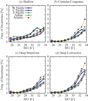
Sea surface temperature (SST) is another important factor that controls
tropical precipitation as indicated in the left figure.
General trend is simple: the higher SST is, the more often rainfall occurs.
The sensitivity to SST, however, is diverse among the different
storm categories.
The Shallow category prevails over the entire range of tropical SST,
showing a slight increase with SST.
Deep Convective systems do not develop at all for SSTs lower than about
26oC, but sharply rise in number as SST increases for warmer
ocean surfaces.
Shallow cumulus is virtually the only member of tropical precipitation
for cold SSTs, while deep systems are dominant over others for warm SSTs.
The turnover occurs around 28-29oC,
which does not strongly depend on regions.
Data archives
Publications related to this topic
- Variability in the Characteristics of Precipitation Systems in the
Tropical Pacific. Part I. Spatial Structure.
Masunaga, H., T. S. L'Ecuyer, and C. D. Kummerow
J. Climate, Vol. 18, pp. 823-840, 2005.
[PDF]
©
2005 American Meteorological Society
- Variability in the Characteristics of Precipitation Systems in the
Tropical Pacific. Part II. Implications for Atmospheric Heating.
L'Ecuyer, T. S., H. Masunaga, and C. D. Kummerow
J. Climate, Vol. 19, pp. 1388-1406, 2006
[PDF]
©
2006 American Meteorological Society
- Observations of Tropical Precipitating Clouds Ranging from
Shallow to Deep Convective Systems.
Masunaga, H., and C. D. Kummerow
Geophys. Res. Lett., Vol. 33, L16805, doi:10.1029/2006GL026547
[PDF]
©
2006 American Geophysical Union
Back to Research Page
*1: The Tropical Rainfall Measuring Mission (TRMM) is
a joint U.S. and Japan project aimed at measuring precipitation thoroughly
across the Tropics.
The TRMM satellite is still in operation since it was launched in November
1997 from Tanegashima, Japan.
Five sensors including Precipitation Radar (PR), TRMM Microwave Imager (TMI),
and Visible/Infrared Scanner (VIRS) are onboard the TRMM satellite.
Further information on the TRMM is available from the
TRMM channel provided by the Japan Aerospace Exploration Agency (JAXA)
Earth Observation Research Center (EORC) or the
TRMM web site provided by
National Aeronautics and Space Administration (NASA) Goddard Space Flight
Center (GSFC).
*2:
The El Niño/Southern Oscillation (ENSO) is a seesawing pattern
repeating between two distinct climate states in the tropical Pacific Ocean.
The period of the ENSO cycle irregularly drifts across the range
between a year and several years.
In the "normal" ENSO phase, cold sea water brought by upwelling in the East
Pacific is gradually heated up by insolation as it travels westward blown
by the trade wind,
resulting in a consistent east-west gradient of sea surface temperature (SST).
This transpacific SST gradient is typically associated with large-scale ascent
responding to active convection over the West Pacific warm pool and
subsidence in the East Pacific (i.e., the Walker circulation).
Every part of the tropical climate system goes "wrong" during El Niño.
The trade wind and eastern Pacific upwelling weaken, the warm pool and
heavily raining region shift eastward away from the West Pacific,
and the ascending branch of the Walker circulation is rooted on the
Central Pacific ocean.
El Niño directly affects fishery near South American coasts and
moisture supply to Southeast Asia, and indirectly influences midlatitude and
highlatitude climate.
The El Niño phase is often followed by the other extreme state called
La Niña before it eventually settles in the normal condition.