Kelvin wave, Rossby wave, and MJO
A wave triggered by a pebble thrown into a pond is a gravity wave.
Gravity waves also propagate through the atmosphere in a similar (but
not exactly the same) way.
The Kelvin wave is a special case of gravity wave bound near the
equator, propagating only eastward.*1
Planetary atmosphere has another intrinsic wave mode called Rossby
wave, or the slow westward movement of large eddies cause by a
latitudinal gradient in the Coriolis force.
The family of equatorial waves, originally theorized by Taroh Matsuno in 1966,
consists of a series of gravity waves including the Kelvin wave,
the equatorial Rossby (ER) wave, and a mixed mode of these two.
 In early 1970's, Roland Madden and Paul Julian discovered an eastward
propagating mode recorded in weather station data over the Tropics.
They named this mode as "the 40-50-day oscillation" after its oscillatory
period, which is now better known as the Madden-Julian Oscillation or
MJO.
The MJO has drawn increasing attention as it turned out to be
the most outstanding component of tropical intraseasonal variability.
Our understanding of the MJO has been improved by many successful studies
for the past 30+ years.
Nevertheless, it would be fair to say that no single theory has succeeded yet
in explaining every aspect of the MJO.
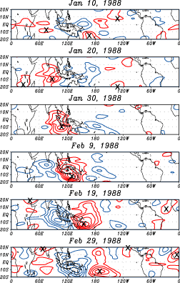
The figure on the right shows a series of MJO snapshots identified from
bandpass-filtered data of satellite-observed outgoing longwave radiation
(OLR)*2.
Red (blue) contours show the wet (dry) phase of the MJO.
An MJO event is initiated in the Indian Ocean on Jan 10, and gains its
intensity as it propagates eastward.
Convective activity associated with this MJO reaches its maximum
when it arrives in the West Pacific (Feb 19).
The MJO weakens and finally disappears as it moves further beyond the dateline.
This is the typical life cycle of the MJO during austral summer.
The potential roles of the Kelvin and ER waves in MJO propagation are then
investigated by a composite analysis described as follows.
The geographical center of MJO convection, hereafter called the base point
("x"s in the figure), is first identified in each snapshot.
The next to do is to look around east and west standing on the
base point to find the Kelvin and ER waves,
defined again by filtered OLR using proper bandpass filters.
Repeating this procedure over 25 years of OLR data,
a number of snapshots, longitudinally offset to the base point, are averaged
together.
 The next figure is a composite diagram for the austral summer MJO,
where zero on the abscissa corresponds to the base point.
The Kelvin wave (colored) is found to stay in the west of the MJO ten days
before the MJO convection peak.
The Kelvin wave reaches closer to the MJO when the MJO is most active (Day 0),
and extends further to the east as another ten days pass.
The ER wave (contoured) is loosely peaked around the MJO, showing no noticeable
evolution throughout the period shown here.
It is as if the ER wave awaited an incoming Kelvin wave approaching from
the west prior to the MJO convection peak. MJO convection is then peaked
when the Kelvin wave finally encounters the ER wave.
 An individual MJO episode together with the Kelvin and ER waves is analyzed
from Tropical Rainfall Measuring Mission (TRMM) satellite
data*3.
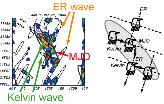
The left figure is a time-longitude diagram of TRMM-observed deep storm
fraction or the area fraction of Deep Stratiform and Deep Convective
systems (see here for definitions).
This MJO event is accompanied with a pair of subsequent ridges of the
Kelvin wave.
The first ridge is interrupted by an incoming ER wave, leaving behind
a quasi-stationary convective period until another ridge of the Kelvin wave
comes in.
The second Kelvin wave emanates to the east until it is interrupted again by
the ER wave near the dateline.
Other several MJO episodes studied (not shown here) exhibit similar
characteristics of the Kelvin and ER waves tangled within the MJO envelope.
This result, in addition to the composite analysis presented earlier,
seems to suggest that the Kelvin and ER waves interacting with each other may
play a key role in the propagation mechanism of the MJO.
Publications related to this topic
- The Madden-Julian Oscillation Recorded in Early Observations from
the Tropical Rainfall Measuring Mission (TRMM).
Masunaga, H., T. S. L'Ecuyer, and C. D. Kummerow
J. Atmos. Sci., Vol. 63, pp. 2777-2794, 2006
[PDF]
©
2006 American Meteorological Society
- Seasonality and Regionality of the Madden-Julian Oscillation,
Kelvin Wave, and Equatorial Rossby Wave.
Masunaga, H.
J. Atmos. Sci., Vol. 64, pp. 4400-4416, 2007
[PDF]
©
2007 American Meteorological Society
- A 9-season TRMM observation of the Austral Summer MJO and
Low-frequency Equatorial Waves
Masunaga, H.
J. Meteor. Soc. Japan, 87A (Special issue on
Precipitation Measurements from Space), 295-315.
[PDF(8.4Mb)]
©Meteorological Society of Japan
Back to Research Page
*1: The Kelvin wave in ocean currents
can travel along coast lines as well as the equator.
*2: OLR well represents the temperature distribution
over the globe as seen from the space. OLR is a useful proxy of severe
storms because cold cloud tops of deep convection are clearly traceable in OLR.
The OLR dataset used here was derived from infrared window channel (10-13
microns) radiance measured by the National Oceanic and Atmospheric
Administration (NOAA) satellites, provided by NOAA Climate Diagnostics Center.
*3: The Tropical Rainfall Measuring Mission (TRMM) is
a joint U.S. and Japan project aimed at measuring precipitation thoroughly
across the Tropics.
The TRMM satellite is still in operation since it was launched in November
1997 from Tanegashima, Japan.
Five sensors including Precipitation Radar (PR), TRMM Microwave Imager (TMI),
and Visible/Infrared Scanner (VIRS) are onboard the TRMM satellite.
Further information on the TRMM is available from the
TRMM channel provided by the Japan Aerospace Exploration Agency (JAXA)
Earth Observation Research Center (EORC) or the
TRMM web site provided by
National Aeronautics and Space Administration (NASA) Goddard Space Flight
Center (GSFC).
 In early 1970's, Roland Madden and Paul Julian discovered an eastward
propagating mode recorded in weather station data over the Tropics.
They named this mode as "the 40-50-day oscillation" after its oscillatory
period, which is now better known as the Madden-Julian Oscillation or
MJO.
The MJO has drawn increasing attention as it turned out to be
the most outstanding component of tropical intraseasonal variability.
Our understanding of the MJO has been improved by many successful studies
for the past 30+ years.
Nevertheless, it would be fair to say that no single theory has succeeded yet
in explaining every aspect of the MJO.
 The next figure is a composite diagram for the austral summer MJO,
where zero on the abscissa corresponds to the base point.
The Kelvin wave (colored) is found to stay in the west of the MJO ten days
before the MJO convection peak.
The Kelvin wave reaches closer to the MJO when the MJO is most active (Day 0),
and extends further to the east as another ten days pass.
The ER wave (contoured) is loosely peaked around the MJO, showing no noticeable
evolution throughout the period shown here.
It is as if the ER wave awaited an incoming Kelvin wave approaching from
the west prior to the MJO convection peak. MJO convection is then peaked
when the Kelvin wave finally encounters the ER wave.
 An individual MJO episode together with the Kelvin and ER waves is analyzed
from Tropical Rainfall Measuring Mission (TRMM) satellite
data